Salisbury Footbridge 1887-2010
Aorere River’s powerful floods have shaped the history of Bainham’s bridges, with five different crossings built—and many swept away—since 1887. Here is a timeline of the Salisbury bridge and other bridges at the gorge on the Quartz Range Road.
Bridges come and bridges go, especially in Bainham, where the Aorere River in a raging flood can leave a trail of destruction. The upright wooden straining posts of the 1902 suspension bridge, the second footbridge in this location, can still be seen in the gorge. This bridge was swept away in a flood in 2010.
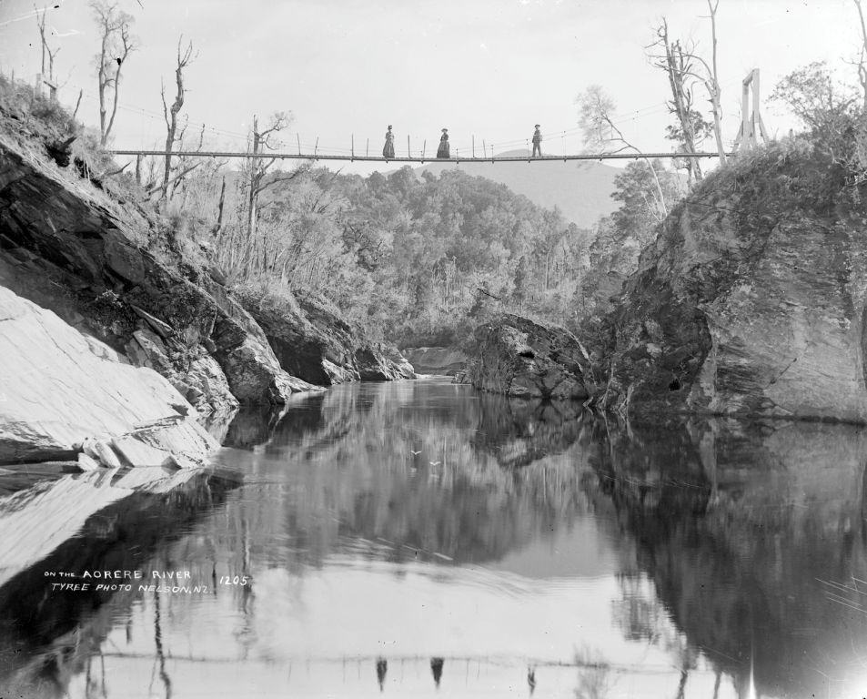 On the Aorere River. Tyree Collection 181884. Nelson Provincial Museum. Of the five bridges built to span this gorge, this was the earliest: a footbridge built in 1887 and destroyed in an 1899 flood. A suspension footbridge was the only means of crossing the upper Aorere River until Jack Flowers built a temporary vehicle bridge in 1956. Click image to enlarge
Active gold mining had occurred in the Quartz Ranges to the south of the Aorere as early as 1857.1 It continued through the depression of the 1930s and casual fossicking still takes place in Salisbury Creek. During New Zealand’s colonial period settlers lobbied councils and government to provide roads and bridges to enable access for mining, milling and farming.
A track for horse and cart had been formed to the north of the Aorere by 1862, as far as “Salisbury’s creek junction,” to provide access for miners into the Quartz Ranges. However, miners then had to cross the river, and a bridge was the logical way to prevent drowning. When the locals finally got their bridge, in 1882, it was not the bridge they wanted. A correspondent to the Golden Bay Argus pointed out that to build a footbridge for 220 pounds was short-sighted, because for 400 pounds a bridge capable of carrying pack-horses could be built. However, the cheaper option was eventually chosen and built under contract by J.R. Rees. Completed in March 1887, the first bridge provided a vital link to the Quartz ranges goldfields. That original bridge was swept away by a massive flood in 1899 and replaced by another in 1902. It would last 108 years, and was the only means of public access until the mid 1980s.
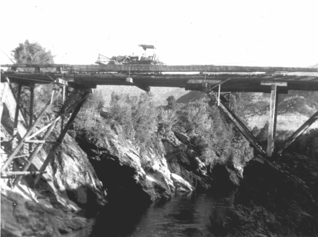 Flowers Bridge. Courtesy Price family
Click image to enlarge
Flowers’ Bridge (left), the first of the vehicular bridges across the gorge, was built in 1956 to take rimu logs from across the river to Jack Flowers’ Aorere Timber Co. mill in Bainham. It was constructed by Don Kelly from Blackball, from beech with three huge lengthwise rimu stringers, all milled from the Quartz Ranges and cost 800 pounds. Kelly and his gang built it in only 90 days without any scaffolding or staging, by using an aerial cableway. Built to take 20 tons, it was 160 feet long, 45 feet above the river, and anchored by 1.5-inch steel cables from old West Coast dredges.
The construction was not intended to be permanent, and the bridge was demolished about five years later, when the timbers started to deteriorate.
The footbridge again became a lifeline, this time for farming families, when the new government-funded road bridge upstream, opened in 1982, was swept away in a flood on the night of 10 January 1985. The locals – some of whom had warned the bridge-builders that the bridge was too low – could rightly say “we told you so”. Another road bridge was built at a higher level and opened in early October 1985, not surprisingly with little fanfare.
Salisbury footbridge was again the subject of local lobbying in 2003, this time to have it restored after it was deemed unsafe for public use. A government grant was made available and the restored bridge reopened on 26 June 2004, followed by a sumptuous afternoon tea in the Bainham Hall. As it turned out, that was the final public celebration of the bridge’s importance to a remote community. On 28 December 2010 nature would have the last word, when the bridge was swept away in a huge 13.75 metre flood on 28 December 2010 only six years after being restored and becoming one of Golden Bay’s tourist icons.
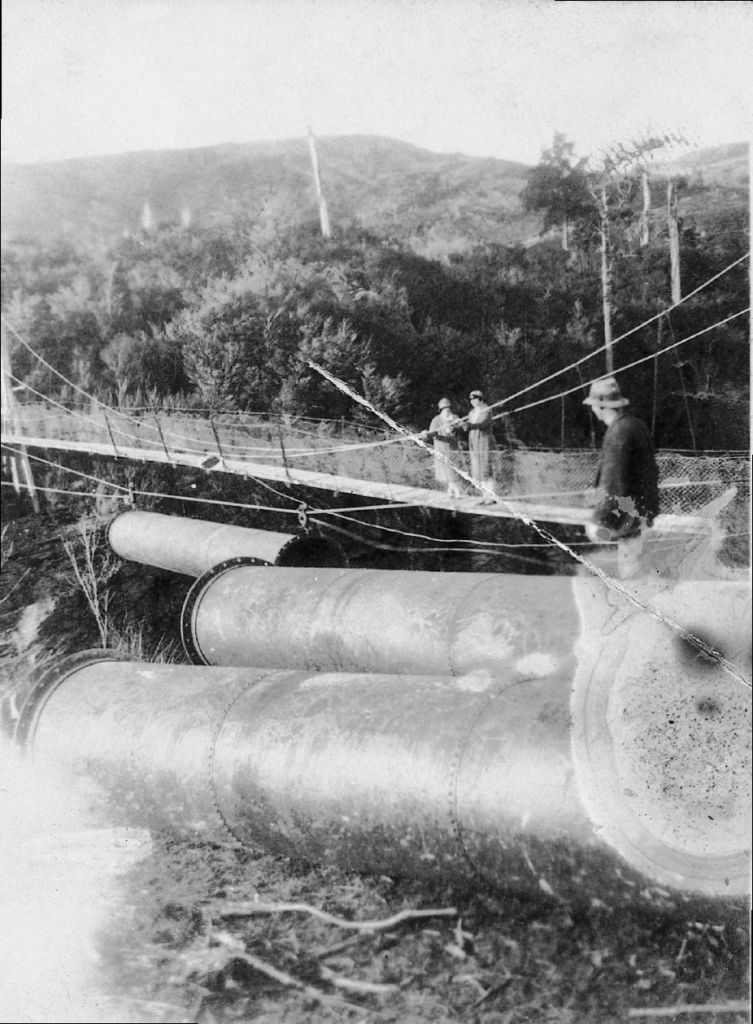 Olive Field and Renie Grant watch from the second (1902) Salisbury Footbridge as Les Grant prepares to swing another huge iron pipe across the Aorere River using wire ropes, block and tackle. In 1922 the pipes from the old gold sluicing claim on the Quartz Ranges (originally brought from Dunedin in 1899) were retrieved for use in other local sluicing operations. Courtesy Etheredge family
Click image to enlarge
Salisbury Creek downstream and the footbridge were named after the Salisbury family, descendants of brothers John and Charles Salisbury who came to the area to seek their fortunes from gold about 1860. The two-storey homestead still standing at the nearby bend in the river was built by the family in 1903. The property is still known as Armchair Farm.
The Salisbury footbridge was registered as a category 2 historic place by the New Zealand Historic Places Trust 2000-2011 (NZHPT Class II Historic Place, Reg. 5123; and has since been deregistered).
A timeline of the Salisbury bridge and other bridges at the gorge on the Quartz Range Road (2013)
- 1881: Inquest into 5 April drowning concluded “it is desirable that a wire footbridge be erected over the Aorere at Salisbury Creek junction.”2
- 1886: Tenders called;3 eligible for subsidy which was not applied for.4
- 1887: Earliest footbridge constructed, for ₤220. There was criticism for not spending ₤400 on a bridge strong enough for packhorses. Delays in bridge being built – grant made October 1885. Provided access for mining.5 There are two known photos of this first footbridge, both taken by the Tyree Brothers: one is held at Alexander Turnbull Library and one at Nelson Provincial Museum.
- 1899 (30 January): Storm/flood, apparently of similar intensity to 28 December 2010, damaged the Salisbury bridge, and washed away the Kaituna suspension bridge.6
- 1902: New footbridge constructed; grant of ₤325.7 We have the specifications for this construction, which lasted until 28 December 2010.
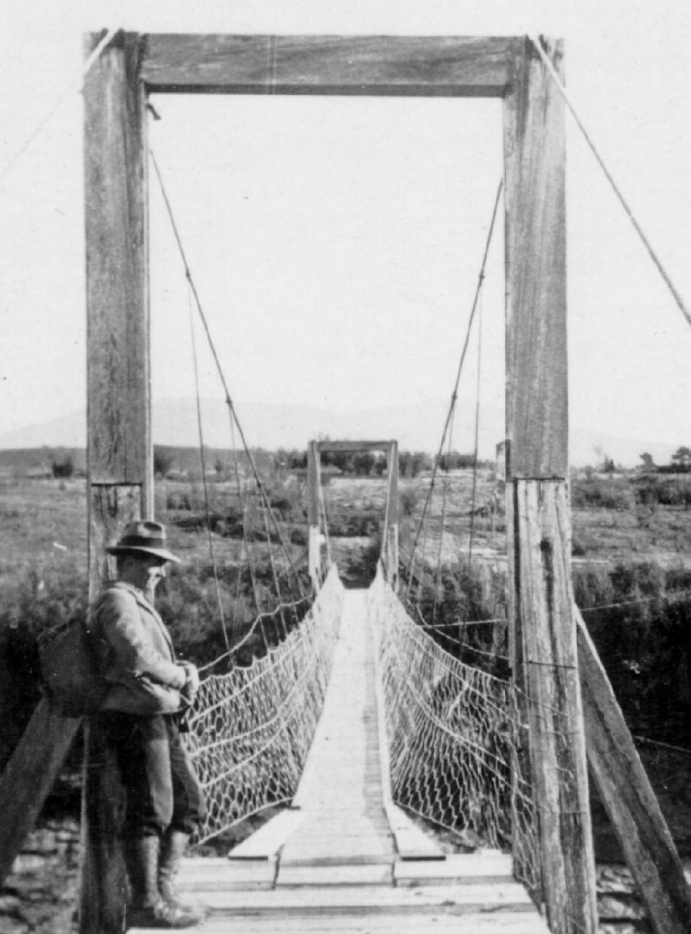 Alan McArthur at the Salisbury Footbridge in 1932. He and several other Hutt Valley (Wellington) workers had been laid off the previous year and were forced to take relief work. The gold subsidy scheme attracted them to the Quartz Ranges diggings, where they dug and sluiced for gold in harsh conditions for eight months. Courtesy McArthur family
Click image to enlarge
- 1945: Repairs carried out.8 The 1887 and 1902 suspension footbridges were the only means of access across the gorge from 1887 to 1982, apart from the short-lived private Flowers’ Bridge (1956-ca1961)
- 1956: Flowers’ vehicular bridge built over the Aorere near Salisbury Creek to remove logs for transport to the Aorere Timber Co. mill at Bainham.9 It was removed ca.1961.
- 1961-1982: Suspension footbridge again the only means of access.
- 1982 (March): Lands & Survey Road bridge opened up the Quartz Ranges land.
- 10 January 1985: the 1982 road bridge (built too low) was washed away.10
- January-October 1985: The suspension footbridge was again the only access to Quartz Ranges farms.
- October 1985: Replacement road bridge opens (still in place, September 2013)
- 1990: Footbridge registered with New Zealand Historic Places Trust as Historic Place, Category II.
- 1995-2002: Inspections, reports, repairs, resulting from April 1995 flood damage and timber deterioration.11
- 2003/4 (from approx. June 2003 to Feb 2004): Tasman District Council (TDC) mid-year decision to close the bridge.12 Heritage Subcommittee Chair Grahame Anderson speaks out criticising TDC’s lack of commitment to heritage. Various estimates of what money is needed for repairs, load testing etc. A report is prepared October 2003. Community asked to raise funds for restoration. Bridge closed December 2003. Mayor Hurley reported as saying TDC wanted the bridge “off its books” as it was unsafe and a liability.13
- Golden Bay Community Board obtains $40,000 from central government Tourism Facilities Fund, with support from local MP Damien O’Connor. Conditions of this grant were for ongoing maintenance by TDC and appropriate tourism road signage.
- 2004 (26 June): Footbridge reopened and celebrated by an amazing afternoon tea at Bainham Hall.
- 2005: TDC funded a small heritage information panel as part of the Trafalgar Bicentenary commemorations. Road signage took a couple of years to eventuate and getting the carpark area made usable (from a quagmire) was another long struggle.
-
2009 (27 January): Report to Peter Thomson (TDC Roading Asset Manager) by Geoff Ward (MWH) includes photos of decay and details of vandalism (e.g. removal of safety notices). The inspection resulted in the bridge being closed for a week and reported urgent work to be carried out by July.14
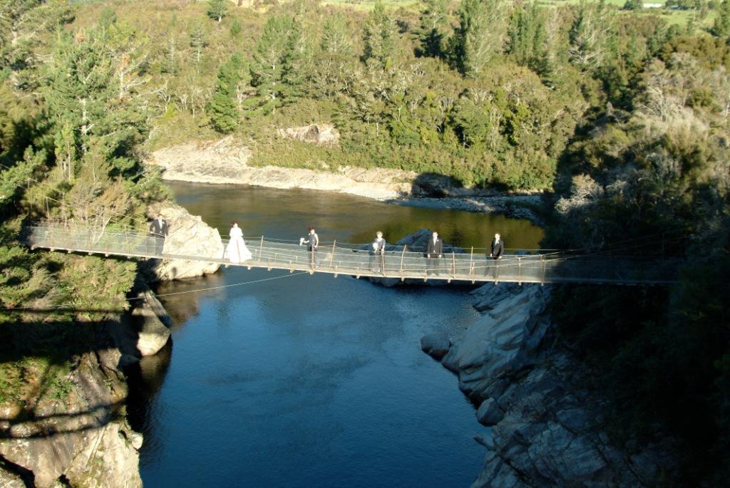 Over the years Salisbury Footbridge attracted many visitors and special events. Here, a local wedding group – groom Craig Harvey and his bride Melinda McLennan- capture their special moment on the bridge in April 2004. The footbridge itself had hardly changed since the first suspension bridge constricted 117 years earlier in 1887. However, the vegetation has definitely thrived in this high rainfall area, a consequence of no more burning of the land for grazing. Courtesy Harvey family.
Click image to enlarge - 2009 (June-Sept): the Bridge and Drummond Report is discussed at TDC Engineering Services Committee meetings. General attitude of Council is unsupportive.
- 2010 (28 December): Salisbury Footbridge demolished by logs swirling through the gorge in the major flood event.
- 2011 (12 January): NZ Historic Places Trust (NZHPT) writes to TDC commenting on the damage and stating its position—recommends that the remaining tower be left standing as a “reminder”. Also commends TDC for recognising the historic worth of the bridge and for tackling the repairs and maintenance over the preceding 18 months.
- 2011 (23 June): NZHPT deregisters Aorere River Swingbridge (Record no. 5123) as a historic place.15
- 2012 (October): Funding received from TDC for an information panel ($1500: Grants from Rates; $1500: Engineering Services)
- 2013 (August): Information panel installed near Quartz Range Road bridge. It records the stories of all five bridges, of which now only one remains. The long-term vision is to incorporate the roadside panel with a walkway to Salisbury Creek, improving access to Salisbury Creek and the public toilet, currently accessed over a stile.
- 2013 (September): request to TDC (via Golden Bay Community Board, 10 September) to amend existing tourism signage (to “Site”) and reinstate signage on main Aorere Valley sign.
The text is displayed on a panel created for Tasman District Council, 2013, from research by Penny Griffith. The image of Flowers Bridge and the 1902 and 1932 bridges are reproduced courtesy Bainham Reunion Committee and River Press.
Updated March 21, 2025
Story by: Penny Griffith
Sources
- Colonist, 15 December 1857
- Nelson Evening Mail, 14 April 1881
- Colonist, 13 November
- Golden Bay Argus, 30 July 1886
- Dawber, C. (1997) Bainham: a history. Picton, N.Z. : River Press. p. 52; Golden Bay Argus April 1886.
- Nelson Evening Mail, 2 February 1899
- Dawber, p. 52; Newport, J.N.W. (1975) Golden Bay: 100 Years of Local Government, Nelson, NZ., Golden Bay County Council, p. 65; Thornton, G. (2001) Bridging the gap: early bridges in New Zealand 1830-1939. Auckland, NZ: Reed, pp.194-5
- Thornton, p.195
- Dawber, p.156, p.159 has further information; quotes Nelson Mail ‘Country Life’, April 1956.
- Dawber, pp.234-6
- Report by Philip Drummond to Tasman District Council, 27 July 2009
- TDC Heritage Subcommittee minutes, 18 July 2003
- Nelson Mail, 11, 23, 27 December 2003
- Nelson Mail, 27 June 2009
- NZ Historic Places Trust letter, 5 July 2011
Further Sources
Books
- Dawber, C. (1997) Bainham: a history. Picton, N.Z. : River Press.
http://www.worldcat.org/oclc/45116082 - Johnston, M. R. (2023). Aorere gold : the history of the Golden Bay goldfields New Zealand, 1856-1863. Nikau Press.
https://search.worldcat.org/en/title/1374330295 - Newport, J. N. W. (1971). Collingwood: a history of the area from earliest days to 1912. Printed at the Caxton Press.
https://search.worldcat.org/en/title/379808 - Newport, J.N.W. (1975) Golden Bay: 100 Years of Local Government, Nelson, NZ., Golden Bay County Council.
http://www.worldcat.org/oclc/4809463 - Salisbury, J. N., & Salisbury, J. P. (2006). Bush, boots and bridle tracks: the Salisburys, pioneers of the Motueka and Aorere Valleys. J. Neville Salisbury.
https://search.worldcat.org/en/title/156378245 - Thornton, G. (2001) Bridging the gap: early bridges in New Zealand 1830-1939. Auckland, NZ: Reed
http://www.worldcat.org/oclc/51059446
Maps
- Drummond, Philip (2009, July 27). Salisbury Historic Footbridge (Aorere). Report to Tasman District Council.
https://www.tasman.govt.nz/document/serve/Report%2020090727%20Salisbury%20Footbridge.pdf?DocID=28219