The Tangata Whenua Tribes of Te Tau Ihu
There are eight tribes in the Top of the South Island, Te Tau Ihu, which tells of a rich and complex past, present and future
There are eight iwi which are tangata whenua in Te Tau Ihu - or Te Tauihu as it is now more commonly known:
- Rangitāne o Wairau, Ngāti Kuia and Ngāti Apa ki te Rā Tō are of Kurahaupō waka origins. They were the tangata whenua of Te Tau Ihu when the Kawhia–Taranaki tribes migrated to the district.
- Ngāti Toa Rangatira, Ngāti Koata, Ngāti Rārua descend from the Tainui waka. They migrated to Te Tau Ihu in the 1820s and 1830s from their original rohe in the Kawhia and Taranaki districts.
- Ngāti Tama ki Te Tau Ihu are of Tokomaru waka origins. They migrated from Northern Taranaki in the 1820s and 1830s.
- Te Ātiawa o Te Waka-a-Māui are of Aotea or Kurahaupō descent, and also migrated in the 1820s and 30s from Northern Taranaki.
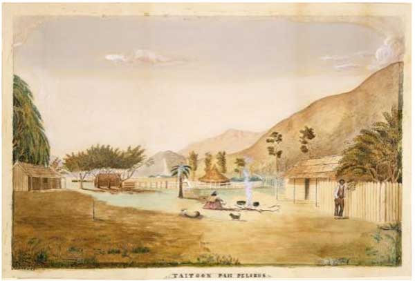 Murray J. P. fl 1880-1890s :Taitook Pah Pelorus. [ca 1880] Alexander Turnbull Library (C-126-014). [Permission must be sought of ATL prior to further use of this image]
Click image to enlarge
Ngāti Kuia descend from three ancestors who disembarked from the Kurahaupō at Te Tai Tapu in north-west Nelson as the waka circumnavigated Aotearoa upon arrival from Hawaiki in the thirteenth or fourteenth century. Kuia migrated eastwards and eventually established settlements in the Pelorus Valley and Sound (Te Hoiere), at Rangitoto ki te Tonga / D'Urville Island and along the eastern coast of Tasman Bay / Te Tai-o-Aorere.
Rangitāne migrated south from Wairarapa in the sixteenth century, led by chiefs who traded land at Wairarapa for waka to travel to the South Island. Through skirmishes and shifting alliances they consolidated their position in the Wairau, Tōtaranui/Queen Charlotte Sound, Awatere and the northern Kaikoura Coast.
A few Ngāti Apa first crossed to the outer Sounds from the Rangitikei district in the late seventeenth century. Further contingents from the Rangitikei, Manawatu and Kapiti districts mounted a sizeable assault on Ngāti Tumatakokiri in western Te Tau Ihu in the late 1700s, eventually ousting Tumatakokiri. After Tumatakokiri’s comprehensive defeat by Apa, Kuia and Ngāi Tahu in about 1810, Apa consolidated their holdings from the Waimea west to Mohua/Golden Bay and Buller, as well as in Tōtaranui/Queen Charlotte Sound.
Kuia, Rangitāne and Apa were dramatically displaced as manawhenua iwi (having authority over the land) when they were defeated by the alliance of Tainui and Taranaki iwi (Ngāti Toa, Ngāti Koata, Ngāti Rarua, Ngāti Tama, Te Ātiawa) between 1828-1832, although they retain their tangata whenua status.
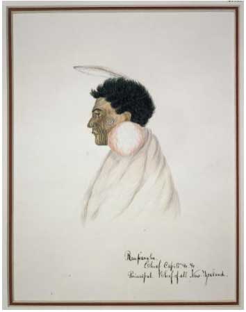 Coates, Isaac (1808-1878): Rauparaha. Chief Capiti. &c. &c. Principal chief of all New Zealand. [1843?] Alexander Turnbull Library (A-286-012)
Click image to enlarge
Ngāti Toa, Ngāti Koata and Ngāti Rarua, had been forced to abandon their lands around Kawhia Harbour in 1821 by their better-armed Tainui cousins, Waikato and Ngāti Maniapoto. After a ten-month stay in north Taranaki with relatives (Ngāti Tama, Ngāti Mutunga and Te Ātiawa), which was spent planting and harvesting crops, hunting, fishing and preserving foods, the Toa chief, Te Rauparaha, led Te Heke Tataramoa down the west coast of the North Island. This was named the Bramble Bush Expedition, because of the difficulties of the journey.
The Kawhia tribes and contingents of Ngāti Tama, Mutunga and Te Ātiawa conquered and occupied the districts of Rangitikei, Manawatu, Horowhenua, Otaki, Kapiti, Porirua and Whanganui-a-Tara/ Wellington. After establishing themselves there, the allies (minus Mutunga who had migrated to the Chathams) turned their attention to the South Island to exact utu on Kurahaupō who had challenged them at Kapiti, and to avenge insults.
Ngāti Koata settled as a result of a tuku (the concession) from Tutepourangi, an ariki (paramount chief) of the Kurahaupō tribes. Between 1828 and 1832, war parties from the other Northern iwi (Ngāti Toa, Ngāti Rarua, Ngāti Tama and Te Ātiawa) conquered Te Tau Ihu as far south as Kaiapoi and Okarito and settled alongside Ngāti Koata and the defeated Kurahaupō peoples. Iwi subsequently agreed on the division of lands, while those Kurahaupō who survived were enslaved or withdrew to inland hiding places.
The division of land, which is now acknowledged as being of particular cultural, spiritual, historical and traditional association with each iwi in Te Tau Ihu, was as follows:
- Ngāti Toa and some Ngāti Rarua occupied the Wairau, Te Whanganui / Port Underwood, and the northern Kaikoura Coast.
- Te Ātiawa spread throughout Tōtaranui/Queen Charlotte Sound and Tory Channel / Kura Te Au.
- Ngāti Koata settled at Rangitoto/D'Urville Island, the Croisilles and outer Pelorus,
- Ngāti Toa stayed in Pelorus Valley and the inner Sound (Te Hoiere).
- Ngāti Tama got Wakapuaka
- Ngāti Rarua, Te Ātiawa and some Ngāti Tama occupied Motueka, Mohua/Golden Bay and Te Tai Tapu (on the west coast south of Farewell Spit).
The Rohe of the iwi of Kurahaupō waka origins remain as follows:
- Rangitāne o Wairau - from the mouth of the Wairau River, extending northwards to Cape Lambert, northwest to Rangitoto/d’Urville Island, encompassing Nelson/Whakatū
and Waimea. Following the Motupiko river to the Nelson Lakes (Rotoiti and Rotorua) the southernmost boundary follows the Waiau Toa / Clarence River to its mouth, and then commences a northwards journey through Kekerengu, Cape Campbell, Lake Grassmere/Kapara Te Hau, White Bluffs/Te Parinui o Whiti and Wairau Lagoons. - Ngāti Kuia - land east of a line from Kahurangi Point down to Thompson Pass (South of Lake Rotoroa), and then west of the line from there up to White Bluffs/Te Parinui o Whiti on the Marlborough coast.
- Ngāti Apa ki te Rā Tō's tākiwa extends to six key areas across Te Tauihu - Raukawa Moana/ Tōtaranui (Tarakaipa Hapū); Te Awaiti/ Kaiaua (Tarakaipa Hapū); Te Tai-o-Aorere (Tarakaipa Hapū); Te Taitapu (Tarakaipa Hapū and Pūaha Te Rangi Hapū); Ngā Roto (Tarakaipa Hapū and Pūaha Te Rangi Hapū); Kawatiri (Pūaha Te Rangi Hapū). (see map)
There has been intermarriage between all eight iwi, and they are bound together by whakapapa, co-residence, and overlapping customary rights.
The Tainui Taranaki chiefs negotiated with New Zealand Company officials to allow European settlement.
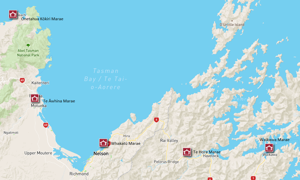
Map of Tasman, Whakatū Marae. Map credit www.māorimaps.com and Te Potiki National Trust Ltd
Marae of Te Tau Ihu and Kakati
There are nine meeting houses for the people of Te Tau Ihu/ Top of the South:
- Whakatū Marae in Nelson - when this Marae was being built in the 1970s, it was recognised that it needed to embrace, in some way, the kaupapa, kawa and tikanga of the six iwi of Whakatū, or Nelson City: Ngāti Kuia, Ngāti Rārua, Ngāti Tama, Te Ātiawa, Ngāti Koata, and Ngāti Toa Rangatira. A common ancestor of the iwi, Kakati, was thus immortalised in the house. Kakati's whakapapa is revealed in John Mitchell's summary: Ko Kakati Te Whare Tupuna Ki Whakatu Marae [PDF], which sheds light on the whakapapa of Te Tau Ihu.
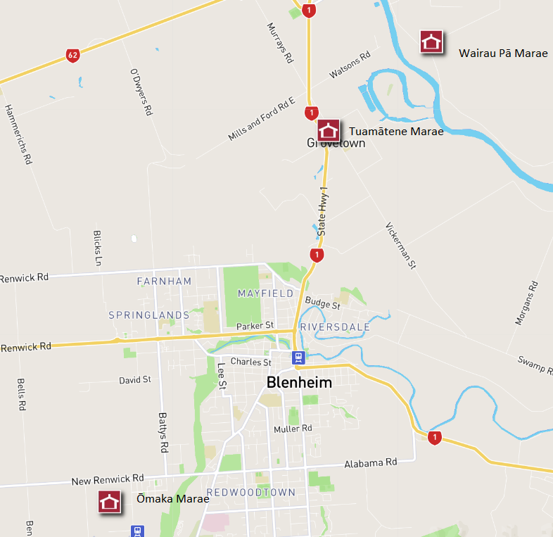
Map of Marlborough Marae. Map credit www.māorimaps.com and Te Potiki National Trust Ltd
- Te Āwhina Marae in Motueka - Ngāti Rārua and Te Ātiawa, Ngāti Tama and Mātāwaka
- Onetahua Kōkiri Marae in Mohua/Golden Bay - Ngāti Rārua, Te Ātiawa
- Te Hora Marae in Canvastown - Ngāti Kuia
- Waikawa Marae in Picton - Te Ātiawa
- Ōmaka Marae in Blenheim - Rangitāne, Ngāti Apa ki te Rā Tō
- Tuamātene in Grovetown - Rangitāne
- Ūkaipō in Grovetown - Rangitāne
- Wairau Pā Marae in Blenheim - Ngāti Rārua, Ngāti Toa Rangatira, Rangitāne
2008 (Updated 2021)
Story by: Hilary and John Mitchell
Sources
- Allan, R: (1954) Nelson: A History of Early Settlement. Wellington : A H & A W Reed, pp22-25.
http://www.worldcat.org/oclc/8650658 - Burns, P: (1983) Te Rauparaha - a new perspective, Auckland : Penguin 1983, pp 135-168.
http://www.worldcat.org/oclc/154277953 - Elvy, J: (1957) Kei Puta Te Wairau: A History of Marlborough in Maori Time, Whitcomb and Tombs, Christchurch : pp71-73, 81.
http://www.worldcat.org/oclc/44404325 - Minute Book No. 2 of the Nelson Native Land Court (1892) pp257-258, 289-290, 302, 309-310. (held Nelson Public Library)
- Mitchell, H & J: (2004) Te Tau Ihu o Te Waka: A History of Maori of Nelson and Marlborough Vol I, The people and the Land Huia Publishers, Wellington, and Wakatu Incorporation, Nelson p64-66, 77-80, 91-95, 100-131, 138-139.
http://www.worldcat.org/oclc/63170610 - Smith, S P: (1910, reprint 1973) History and Traditions of the Taranaki Coast. Wellington, N.Z. : Polynesian Society: pp340-443, 483, 537-551.
http://www.worldcat.org/oclc/152409255 - Smith, S.P.(1910) History and traditions of the Maoris of the west coast, North Island of New Zealand, prior to 1840. New Plymouth, N.Z., Printed for the Society by T. Avery.
http://www.worldcat.org/oclc/5900349
Further Sources
Books
- Allan, R: (1954) Nelson: A History of Early Settlement. Wellington : A H & A W Reed, pp22-25.
http://www.worldcat.org/oclc/8650658 - Burns, P: (1983) Te Rauparaha - a new perspective, Auckland : Penguin 1983, pp 135-168.
http://www.worldcat.org/oclc/154277953 - Elvy, J: (1957) Kei Puta Te Wairau: A History of Marlborough in Maori Time, Whitcomb and Tombs, Christchurch : pp71-73, 81.
http://www.worldcat.org/oclc/44404325 - Minute Book No. 2 of the Nelson Native Land Court (1892) pp257-258, 289-290, 302, 309-310. (held Nelson Public Library)
- Mitchell, H & J: (2004) Te Tau Ihu o Te Waka: A History of Maori of Nelson and Marlborough Vol I, The people and the Land. Wellington: Huia Publishers and Nelson: Wakatu Incorporation,. p64-66, 77-80, 91-95, 100-131, 138-139.
http://www.worldcat.org/oclc/63170610 - Mitchell, H & J (2009) Te Tau Ihu o Te Waka: A History of Maori of Nelson and Marlborough. Volume 3, Nga tupuna = the ancestors. Wellington, N.Z. : Huia Publishers in association with the Wakatū Incorporation
http://www.worldcat.org/oclc/773197494 -
Mitchell, H. (2014) Te tau ihu o te Waka : a history of Maori of Nelson and Marlborough. Vol IV, Nga whanau rangatira o Ngati Tama me Te Atiawa : the chiefly families of Ngati Tama and Te Atiawa. Nelson : Ngati Tama ki Te Waipounamu Trust ; Picton ; Te Atiawa o Te Waka-a-Maui Trust.
http://www.worldcat.org/oclc/1009142678 - Smith, S P: (1910, reprint 1973) History and Traditions of the Taranaki Coast. Wellington, N.Z. : Polynesian Society: pp340-443, 483, 537-551. http://www.worldcat.org/oclc/152409255
- Smith, S.P.(1910) History and traditions of the Maoris of the west coast, North Island of New Zealand, prior to 1840. New Plymouth, N.Z., Printed for the Society by T. Avery.
http://www.worldcat.org/oclc/5900349 - Te Āwhina Marae (2021) Te Āwhina Marae : he rau mahora. [Motueka] : [Te Āwhina Marae]
https://tepuna.on.worldcat.org/oclc/1244158989
Websites
the tribes
- Rangitāne - https://www.rangitane.org.nz/
- Ngāti Kuia - http://www.ngatikuia.iwi.nz/
- Ngāti Apa - http://www.ngatiapakiterato.iwi.nz/
- Ngāti Toa - http://www.ngatitoa.iwi.nz/
- Ngāti Koata Trust - http://ngatikoata.com/
- Ngāti Rarua Atiawa Iwi Trust - http://www.nrait.co.nz/
- Ngāti Tama - https://ngatitama.nz/
- Te Atiawa Iwi Authority - https://teatiawa.iwi.nz/
Maps
Web Resources
- Mitchell, H&J.(2008). Te Tau Ihu tribes, Retrieved from: Te Ara - the Encyclopedia of New Zealand:
http://www.teara.govt.nz/en/te-tau-ihu-tribes - https://forms.justice.govt.nz/search/WT/reports/reportSummary.html?reportId=wt_DOC_68198741
- History of claimants in Te Tau Ihu. Retrieved 8 December 2008 from Tainui Taranaki : Ki te Tonga:
http://www.tainuitaranaki.co.nz/history/ - Te Tau Ihu Statutory Acknowledgements 2014, Nelson City Council, Tasman District Council, Marlborough District Council:
http://nelson.govt.nz/assets/Environment/Downloads/TeTauIhu-StatutoryAcknowledgements.pdf - Te Tau Ihu. Retrieved 8 December 2008, from Te Pune Kokiri:
http://www.tkm.govt.nz/region/te-tau-ihu/ - Te Tau Ihu Treaty Settlement claims passed (2014, April 17). Retrieved from Scoop:
https://www.scoop.co.nz/stories/PA1404/S00316/te-tau-ihu-treaty-settlement-legislation-passed.htm